Green Lagoon


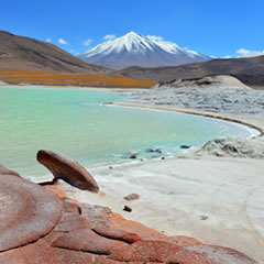
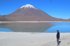
Laguna Verde (Green lagoon) is a high-altitude mineral lake in the Eduardo Avaroa Reserve, known for its beautiful green color. It sits at the foot of 2 volcanoes, Licancabur and Juriques, which straddle the border with Chile and are reflected in the water when the weather is calm.
The Licancabur is a stratovolcano on the border between Bolivia and Chile, south of the Sairecabur volcano and west of Juriques. It overlooks the Green Lagoon and looms over San Pedro de Atacama.
The Green Lagoon is located at 4350 meters above sea level. It has a total surface of 17 km2 and when seen for the first time, it has often been described as a vision of the end of the world.
The Laguna Verde is divided into 2 major bodies of water. The reason for its particular coloring is the high content of magnesium that exists in most of the geologic formations of the area. The landscape is truly fascinating especially when the sun sets on the zenith.
On the shores of the lagoon there are several enormous volcanic black-stones and saline rock formations that seem to be coming from the ground.
It has been impossible to determine the exact depth of this lagoon. Throughout the area there is a large amount of straw, most of which is curled or bent according to the direction of the wind.
While walking around the shore, an amazing view of the whole lagoon can be seen with the various mountains that surround it in the background. This allows visitors to see a beautiful and abrupt contrast of colors and shapes which are reflected on the surface of the lagoon as well.
This is a perfect area for long, peaceful and memorable hikes; it is also a great place for adventure and ecological tourism.
The best dates to vist the Green Lagoon include the months of June, July and August. During these months the soil is fairly dry, which makes it easy to ascend and descend the rocky formations throughout the entire area.
The Licancabur Volcano (5,868 meters above the sea level) has the shape of an almost perfect cone. It is an inactive volcano and it does not have much vegetation (straw and some grass). It is located towards the West end of the Lagoon and it is the landmark that indicates the border line between Chile and Bolivia.
It takes about five hours to climb the Licancabur volcano. It has a very steep and rocky slope, and whoever dares to climb it must face strong currents of wind, which come from the Pacific Ocean. From the summit you can see several deep valleys and the numerous lagoons that are inside and outside the Eduardo Avaroa National Park.